
Map of the surrounding area
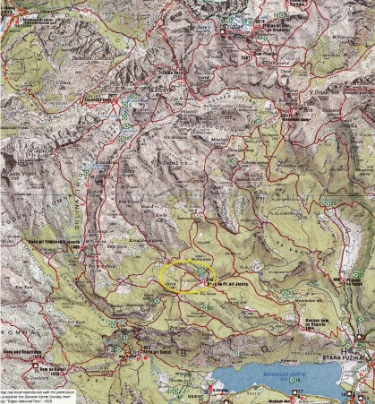
This map has been reproduced with the permission of the publisher, the Slovene Alpine Society, from the map “Triglav National Park”, 1998.
LEGEND ![]() :
:
1. Jezero pod Vršacem (Lake under Vršac), diameter 90 x 60 m, depth 5 m
2. Jezero v Laštah (Lake in Lašte), diameter 40 x 50 m, depth 2 m
3. Rjavo jezero (Brown Lake), diameter 150 x 100 m, depth 10 m
4. Zeleno jezero (Green Lake), diameter 100 x 80 m, depth 2 m
5. Veliko jezero (Great Lake), diameter 300 x 120 m, depth 15 m
6. Dvojno jezero (Double Lake), diameter 120 x 80 m, depth 8 m
7. Črno jezero (Black Lake), diameter 150 x 80 m, depth 6 m
14. Jezero na Planini pri Jezeru (Lake on Planina pri Jezeru), diameter 150 x 100 m, depth 9 m
15. Mlaka pod Vršaki (Pool under Vršaki), diameter 40 x 25 m, intermittent
16. Mlaka v Dolu pod Stadorjem, a smaller intermittent lake in Dol under Stador
17. Malo polje, a swampy alpine karst polje, alpine swamp flora
18. Bohinj Lake, the biggest permanent lake in Slovenia, 6.6 sq km, depth 45 m
20. Mala Savica spring, periodical karst water spouts out of a 60 m long cave
22. Kropa spring, periodical karst water spouts out of a smaller cave, 10 m waterfall
31. Savica spring and waterfall, karst spring falling out of a 120 m long cave in a 51 m high double waterfall
32. Mostnica waterfall, 21 m high
33. Govic, out of a 24 m long and 105 m deep inclined cave a 20 m high waterfall spouts periodically
35. Suha waterfall (waterfall in Drt), 60 m high
42. Mostnica riverbeds, 1 km long and up to 20 m deep
54. Adam and Eve, two rocks on the Jezerski Preval pass
56. Glacier moraines in Stara Fužina, the remains of a glacier dam which created the Bohinj Lake